How Close Is Too Close? Shooting Iceland's Eruptions Without Becoming a Statistic
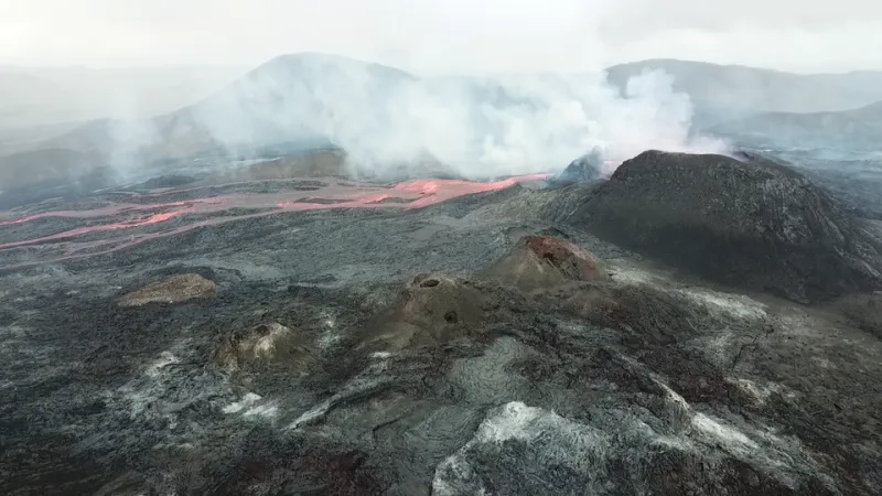
Photo: Mokslo Sriuba, CC BY-SA 4.0, via Wikimedia Commons
There is no photograph you will ever take that looks like the ones coming out of the Reykjanes Peninsula. Molten rock the color of a forging furnace, cracking open the earth in real time, against a landscape so barren it could pass for another planet. When Fagradalsfjall first erupted in 2021, the images went everywhere — and ever since, every new fissure on the peninsula has pulled a fresh wave of US travelers toward Iceland with one goal: get the lava shot.
I get it. I've stood on a ridge above an active fissure field, felt the heat on my face from a half-mile away, and heard lava move — a glassy, grinding sound that no video has ever done justice. It's the most extraordinary thing I've ever pointed a camera at.
It's also a live geological event, not a photo op. And the gap between those two things is where people get hurt.
First, the Uncomfortable Truth About Risk
Let's be clear-eyed about what you're dealing with. An eruption is not a static landscape feature. Fissures can open with little warning. Lava fields collapse. Gases — sulfur dioxide chief among them — are invisible, odorless at dangerous concentrations, and can accumulate in low-lying terrain. The 2023 eruptions near Grindavík and Svartsengi saw lava flows that cut roads and destroyed infrastructure within hours, in areas that had been publicly accessible days before.
Nobody has to be the person who wandered past a closure rope for a shot. The image is never worth it. Say it again: the image is never worth it.
Monitor the Right Sources — Not the Hashtag
Before and during any eruption, your information workflow matters more than your gear list. Bookmark these now:
- Icelandic Civil Defense (almannavarnir.is / safetravel.is): The official source for eruption status, danger zones, and closures. This is the only authority that matters.
- Icelandic Met Office (vedur.is): Seismic activity, gas dispersion forecasts, and wind — updated constantly.
- RÚV: Icelandic national broadcaster with live streams and English-language coverage when activity ramps up.
If a site says closed, it's closed — not 'closed for people who aren't serious photographers.' Local search and rescue teams (ICE-SAR, all volunteers) have pulled far too many overconfident visitors off lava fields already.
Read the Wind Like Your Life Depends on It (Because It Does)
Gas is the hazard most photographers ignore because you can't see it. SO2 plumes drift with the wind, and conditions change fast on the peninsula. The Met Office publishes gas dispersion forecasts — check them every morning and every few hours.
Basic rules:
- Stay upwind of the eruption site, always. If you can smell sulfur strongly, you're in the plume — leave.
- Never descend into valleys, gullies, or depressions near active fissures, even cooled ones. Gas pools there.
- Carry a gas mask rated for acid gases (a P100 with organic vapor/acid gas cartridges) if you're shooting anywhere near active venting. A regular N95 does nothing for SO2.
Gear That Actually Matters
You don't need the longest lens on the planet. You need the right setup for standing in cold, windy, possibly gassy conditions for hours:
- Telephoto in the 100–400mm range for compressed lava-flow shots from legal distances; a 24–70mm for wide environmental frames if access allows.
- Sturdy boots with ankle support — lava terrain is razor-edged, unstable, and unforgiving. Hiking sandals are how people get airlifted.
- Layers plus wind shell. It's Iceland. The temperature differential between the parking area and the ridge is brutal.
- Headlamp and spare batteries — cold kills batteries fast, and many of the best eruption light moments happen in the blue hours.
- Lens cloths, plural. Volcanic ash and fine grit will find every glass surface you own.
The Ethics of Shooting an Ongoing Event
Here's the part that separates photographers from tourists with cameras. An eruption is not a backdrop — it's a disaster in progress for the people who live on the Reykjanes Peninsula. Grindavík residents have lost homes. Businesses have been wiped out. Fisheries and infrastructure have been damaged.
So:
- Don't treat evacuated towns as sets. If an area is closed because residents can't return, photographing yourself in front of it for content is grotesque. Don't.
- Respect local guidance over influencer advice. The person who got the viral drone shot by ignoring a closure is not a model to emulate; they're a warning.
- Drones: only fly where and when permitted, and never over the eruption site — you're a hazard to aircraft monitoring the event and to people on the ground.
- Credit the reality. If you publish eruption work, acknowledge what's happening to the community, not just how epic your frame looks.
The Shot Worth Getting
The truth is, the best eruption photographs I've seen weren't taken by the people who got closest. They were taken by the patient ones — the ones who read the forecasts, waited for the right wind, stood in the legal zone for six hours as the light died, and let the volcano do what volcanoes do.
Fire and ice telling their story is the whole reason we come here. Your job as a photographer is to witness it — not to become part of the incident report.