No Ropes Required: Iceland's Most Jaw-Dropping Volcanic Spots You Can Actually Reach
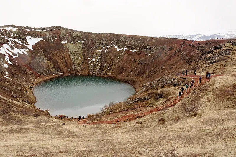
Photo: Jakub Hałun, CC BY-SA 4.0, via Wikimedia Commons
Let's be honest — when most Americans picture Iceland's volcanic landscape, they imagine something from a disaster movie. Lava pouring down cliffs. Scientists in heat-resistant suits. Definitely not something you'd tackle on a family vacation or a solo trip with a moderate fitness level.
Reality check: Iceland's volcanic terrain is extraordinarily accessible. Yes, the island sits atop the Mid-Atlantic Ridge and experiences more volcanic activity than almost anywhere else on Earth. But that geological drama has also created a landscape riddled with craters, lava fields, and volcanic caves that you can explore with nothing more than decent hiking boots and a sense of adventure.
Here's your no-nonsense guide to getting face-to-face with Iceland's fire, starting from the easiest and working up to the slightly more ambitious.
1. Raufarhólshellir Lava Tunnel — Walk Inside a Volcano (Literally)
Difficulty level: Easy. This one's for everyone.
About 30 minutes east of Reykjavik, Raufarhólshellir is one of the longest and most accessible lava tubes in Iceland, formed roughly 5,000 years ago when the outer shell of a lava flow cooled and hardened while molten rock continued flowing inside — eventually draining out and leaving a hollow tunnel behind.
The guided tour takes you roughly 1,400 meters into the tube on a well-lit, developed pathway. You'll see lava stalactites, frozen lava cascades, and ice formations that build up inside the tunnel during winter. The temperature hovers around 37°F year-round, so bring a layer.
Photography tip: The contrast between the dark volcanic rock and the cool blue ice formations deeper in the tunnel is stunning. A wide-angle lens and a camera that handles low light well will serve you much better than your phone here.
Amy Kowalski from Chicago visited with her teenage kids and called it "the most alien place I've ever stood." She added: "My son, who refuses to be impressed by anything, went completely silent in there. That alone was worth the trip."
2. Grábrók Crater — A 15-Minute Hike to the Edge of the Earth
Difficulty level: Easy to moderate. If you can walk up stadium bleachers, you've got this.
Located along Route 1 in West Iceland, Grábrók is a perfectly preserved volcanic crater that you can climb in about 15 minutes on a well-maintained spiral boardwalk. At the top, the crater rim gives you a 360-degree view of the surrounding lava field and the Icelandic highland plateau stretching away to the horizon.
Grábrók is roughly 3,400 years old and part of a cluster of three craters formed during the same eruption. The boardwalk was built specifically to protect the fragile lava field ecosystem while still giving visitors full access — meaning you can focus entirely on the experience rather than worrying about the terrain.
Photography tip: Shoot from the crater rim looking down into the bowl for a perspective that makes the scale of the volcanic event feel real. Early morning light from the east catches the texture of the lava beautifully.
3. Eldborg Crater — A Proper Hike With a Massive Payoff
Difficulty level: Moderate. Plan for about 3 hours round trip.
If Grábrók is the warm-up, Eldborg is where things get seriously impressive. Located on the Snæfellsnes Peninsula — one of Iceland's most photogenic regions — Eldborg is a 200-foot-tall crater rising dramatically from a flat lava plain. The hike to the rim is about 2.5 miles each way over uneven but manageable terrain.
Once you're at the top, the view into the crater is genuinely breathtaking. The walls drop about 60 feet straight down into a perfectly symmetrical bowl. On a clear day, you can see the Snæfellsjökull glacier volcano in the distance.
Photography tip: The approach trail across the lava field, with Eldborg rising in the background, makes for one of the most compositionally satisfying landscape shots in Iceland. Shoot it on the way in when your energy is high and the angle of approach gives you the most dramatic perspective.
Derrick Thompson from Denver hiked Eldborg on his first trip to Iceland. "I'm not a hiker back home. Like, at all," he admitted. "But the trail was totally doable and when I got to the rim and looked down into that crater, I actually got emotional. It felt like I'd earned something real."
4. Fagradalsfjall — Iceland's Newest Volcano (And Yes, You Can Hike It)
Difficulty level: Moderate to challenging, depending on conditions. Check updates before you go.
In 2021, a volcano erupted on the Reykjanes Peninsula — just 25 miles from Reykjavik — for the first time in 800 years. It erupted again in 2022, 2023, and 2024. What was once a quiet hiking area became one of the most visited volcanic sites on Earth, as Icelanders and tourists alike hiked out to watch lava flowing in real time.
The eruption sites around Fagradalsfjall and the nearby Sundhnúkur crater row are now established hiking destinations. The terrain is rugged — hardened lava fields require sturdy boots and careful footing — but there are no technical climbing sections. The hike to the main viewing areas is roughly 2 to 4 miles depending on your starting point.
Critical safety note: Always check the Icelandic Meteorological Office (vedur.is) and the Visit Reykjanes website before heading out. Volcanic activity in this area is ongoing and conditions can change rapidly. Follow all official closures and guidance without exception.
Photography tip: The contrast between the jet-black recent lava and the older moss-covered fields surrounding it is visually extraordinary. Drone photography is restricted in active volcanic areas, but ground-level wide shots of the lava field textures are endlessly compelling.
5. Víti Crater at Askja — The Remote One Worth Planning For
Difficulty level: Moderate, but requires a 4WD vehicle and a full-day commitment.
For travelers willing to venture into Iceland's interior highlands, the Víti crater at Askja is in a category of its own. Víti — which literally translates to "Hell" in Icelandic — is a geothermal crater lake filled with milky blue water warm enough to swim in. It sits adjacent to the massive Öskjuvatn caldera lake, one of Iceland's deepest.
Getting there requires a 4WD vehicle and crossing several river fords, so this isn't a casual day trip. But guided tours from Akureyri and Reykjavik make the journey straightforward even for visitors without off-road experience. The landscape around Askja is so otherworldly that NASA sent Apollo astronauts here to train before the moon landings.
Photography tip: The color contrast between the turquoise Víti lake and the dark volcanic rim is unlike anything else in Iceland. Midday light actually works well here because you want the water color to pop.
Before You Go: A Few Things Every Volcanic Explorer Should Know
- Wear sturdy, ankle-supporting boots. Lava fields are brutally uneven and will destroy trail runners within a single hike.
- Layer up regardless of season. Iceland's weather changes fast. Even in July, wind chill on an exposed crater rim can be significant.
- Tell someone your plan. Iceland's 112.is emergency app is worth downloading before any backcountry hike.
- Stay on marked paths. Lava crusts can be thin and hollow underneath. Marked trails exist for good reason.
- Go with a guide if you're unsure. Iceland has excellent guiding companies that can take you safely to every location on this list.
Iceland's volcanic landscape isn't just a backdrop for adventure — it's the adventure itself. And the best part? You don't need to be an athlete, a climber, or an extreme sports enthusiast to stand at the edge of a crater and feel the deep, humbling power of a planet that's still very much alive beneath your feet.